St. Francis Dam: The 1928 Inquiry Blamed the Rock Beneath It
Published Last substantive revision
How to read this page: each point is marked as a cross-checked fix, a single record (“according to”), or inference (“by dead reckoning”).
TL;DR: A commission appointed by California's governor reported on March 24, 1928, that the failure of the St. Francis Dam “was due to defective foundations,” meaning the rock the dam was built on. It found nothing in the failure to show that the accepted theory of gravity dam design was wrong, and it said all such dams should be built and maintained under state supervision.
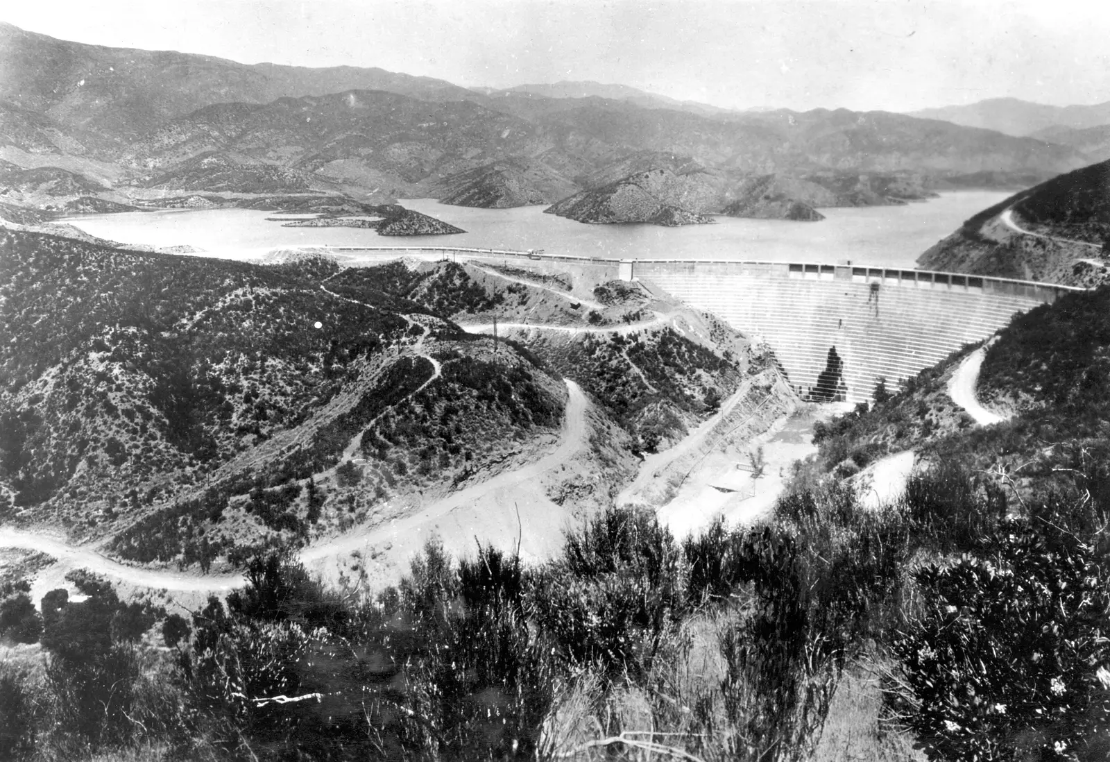
“The St. Francis Dam” by H. T. Stearns, U.S. Geological Survey, Public domain
Full credit
"The St. Francis Dam" by H. T. Stearns, U.S. Geological Survey — https://commons.wikimedia.org/wiki/File:The_St._Francis_Dam.jpg — Public domain (US: work of a U.S. Geological Survey employee in the course of his duties, not protected by copyright (17 U.S.C. 105); EU: rule of the shorter term (Term Directive art. 7(1)) for a work of US origin with no US term; accepted for federal works by site ruling of 2026-11-01)
What failed on the night of March 12, 1928?
In March 1928, the St. Francis Dam in Southern California failed, and only its middle section stayed standing. Construction began in April 1924 and ended on May 4, 1926, less than two years before the failure. Those dates come from the report of the commission Governor C. C. Young appointed to find the cause. Six engineers and geologists sat on it, with A. J. Wiley as chairman.
The dam stood in San Francisquito Canyon, near Saugus, and stored water from the Los Angeles Aqueduct. It was a concrete gravity dam, a type that holds back water by its own weight, and seen from above it curved. The report gives its highest section as 205 feet (62 m) and the length of its crest as 700 feet (213 m). Plans and data came from the city's Bureau of Water Works and Supply, through its chief engineer, William Mulholland.
By March 5, 1928, the reservoir was “practically filled to capacity of 38,000 acre-feet,” nearly three times its 1926 high of 13,200. An acre-foot is the water that would cover one acre to a depth of one foot, so 38,000 of them come to about 46.9 million cubic meters. From then until the failure, the report says, the water was held 0.25 foot (3 inches) below the spillway, the overflow notch at the top of the dam.
According to the report, a caretaker was seen on top of the dam at 11 p.m., and nothing alarming had been noticed. The caretakers died in the flood, and “so far as is known there is no living witness of the dam's collapse.” The commission put the failure “at, or slightly before, 11.58 p.m.” Blocks of concrete weighing up to about 10,000 tons were carried several thousand feet downstream.
Fix: of the main dam, only a section near the middle was left standing. The commission's report says so, and H. T. Stearns's U.S. Geological Survey photograph of March 17, 1928, shows one block upright in the canyon with the dam gone on both sides of it. The wall still on the ridge at left in that view is the wing wall, which the report counts apart from the main dam.
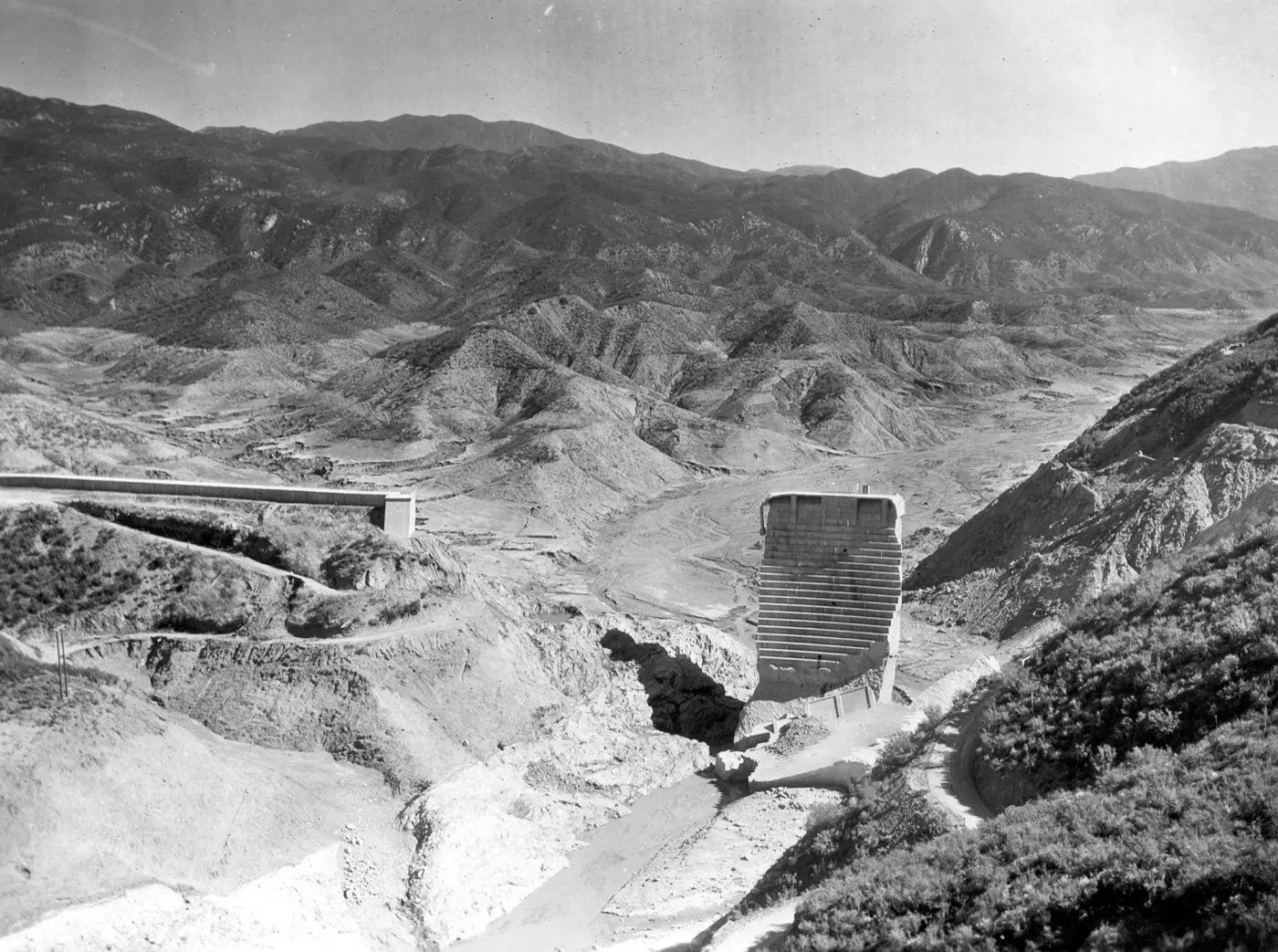
“St. Francis Dam after the 1928 failure” by H. T. Stearns, U.S. Geological Survey, Public domain
Full credit
"St. Francis Dam after the 1928 failure" by H. T. Stearns, U.S. Geological Survey — https://commons.wikimedia.org/wiki/File:St._Francis_Dam_after_the_1928_failure.jpg — Public domain (US: work of a U.S. Geological Survey employee in the course of his duties, not protected by copyright (17 U.S.C. 105); EU: rule of the shorter term (Term Directive art. 7(1)) for a work of US origin with no US term; accepted for federal works by site ruling of 2026-11-01)
The report, dated March 24, 1928, counted the dead only as of that date: “The record of known dead at this time is 236 and 200 are still missing.” It gives no final figure, and none is added here from later compilations. The report names no one as responsible. Mulholland appears in it only as the source of the plans, photographs and construction details the commission used.
How fast did the flood reach the sea?
The commission's best clock was a power line. At 11:58 p.m., the Borel transmission line of the Southern California Edison Company, which ran across the canyon just below the dam, broke. Five minutes later, at 12:03 a.m. on March 13, power from the city's Power Plant No. 2, about 1.5 miles downstream, went off.
The commission took 11:58 p.m. as the moment of failure and timed the flood from there. Its table follows the water down San Francisquito Creek and the Santa Clara River to Montalvo Bridge, which the flood reached at 5:00 a.m. By the report's own mileages, Montalvo was 48.5 miles from the dam. That is an average of under 10 miles per hour over five hours, after a first stretch at 18 miles per hour.
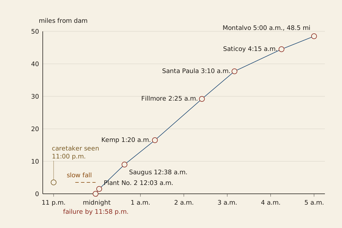
Figure: From the Surviving Record, CC BY 4.0
Full credit line for reuse
"St. Francis Dam flood: arrival times against distance from the dam" by From the Surviving Record, CC BY 4.0. Source: https://fromthesurvivingrecord.com/failures/st-francis-dam/ — License: https://creativecommons.org/licenses/by/4.0/
Data: Report of the Commission appointed by Governor C. C. Young to investigate the causes leading to the failure of the St. Francis Dam (1928), retrieved 2026-11-01, public domain in the United States
| Time | Place | Miles from previous point | Speed from previous point (mph) |
|---|---|---|---|
| 11:58 p.m. | Borel power line at the dam | — | — |
| 12:03 a.m. | City Power Plant No. 2 | 1.5 | 18.0 |
| 12:38 a.m. | Edison substation near Saugus | 7.5 | 12.9 |
| 1:20 a.m. | Edison construction camp at Kemp | 7.5 | 10.7 |
| 2:25 a.m. | Fillmore Bridge | 12.7 | 11.7 |
| 3:10 a.m. | Santa Paula | 8.5 | 11.3 |
| 4:15 a.m. | Saticoy Bridge | 6.8 | 6.3 |
| 5:00 a.m. | Montalvo Bridge | 4.0 | 5.3 |
Each speed in the table was recalculated from its time and distance; all seven match the report's printed figures. Within three-fourths of a mile of the dam, the commission measured a water depth of about 125 feet (38 m). At the Edison camp at Kemp, 16.5 miles downstream, the report says “more than 80 out of about 140 perished.” The report gives the flood's whole course as 52 miles to the sea, though its own legs, 9 miles down the creek and 43.5 down the river, add up to 52.5.
Download the table (CSV, st-francis-dam-timeline.csv) (file notes: sources and license) Data: Report of the Commission appointed by Governor C. C. Young to investigate the causes leading to the failure of the St. Francis Dam (1928), retrieved 2026-11-01, public domain in the United States
One record points to an earlier start. A water register, a gauge that drew the water level on a paper chart, sat on the middle section of the dam. It showed a slow, speeding fall in the water surface from about 11:30 p.m., before the sudden drop. The commission warned that “too much reliance must not be placed upon” the chart, since its clock was uncertain, and it noted that a slow fall did not fit reports of a sudden wave at Power House No. 2.
By dead reckoning, if the chart is right, water was already escaping beneath the dam for about half an hour before the break, which fits the commission's account of a foundation that gave way. The commission's own doubts about the clock limit that reading.
What was wrong with the rock?
The dam was built across a fault: in the report's words, “the dam consequently was placed astride of the fault.” Two commission members, the geologists George D. Louderback and F. L. Ransome, studied the site. The report describes mica schist under the canyon floor and the steep southeast side, and a reddish conglomerate on the gentler northwest side. The two rocks met at the San Francisquito fault, which followed the canyon.
Mica schist is a rock built of thin layers of mineral flakes that split apart easily. The report says the layers here ran close to the angle of the steep southeast slope. The rock was strong when pushed across its layers but weak along them, and under such stresses it “would slip like a pack of cards thrown upon a table.”
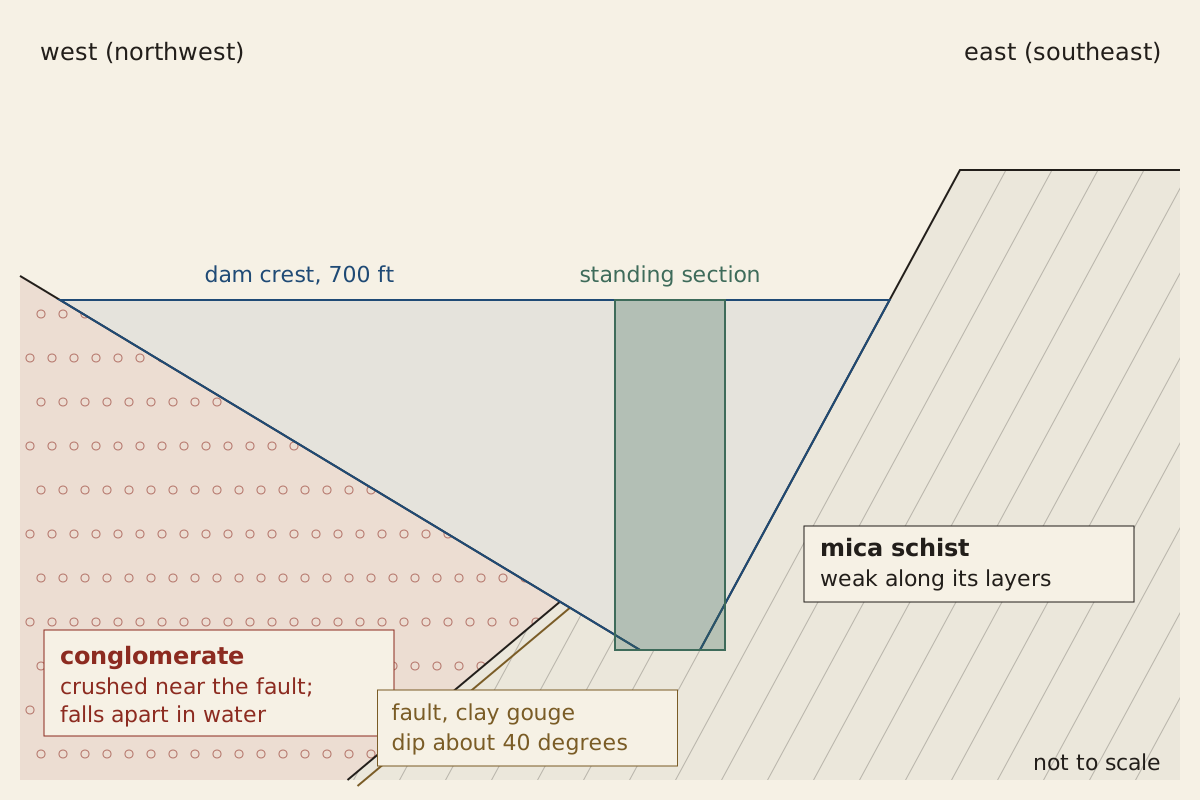
Figure: From the Surviving Record, CC BY 4.0
Full credit line for reuse
"Rock under the St. Francis Dam as the 1928 report describes it" by From the Surviving Record, CC BY 4.0. Source: https://fromthesurvivingrecord.com/failures/st-francis-dam/ — License: https://creativecommons.org/licenses/by/4.0/
Data: Report of the Commission appointed by Governor C. C. Young to investigate the causes leading to the failure of the St. Francis Dam (1928), retrieved 2026-11-01, public domain in the United States
Conglomerate is a rock of pebbles held in finer, cemented grit. Near the fault, the report found it so crushed that it was “held together merely by films of clay.” Dry, it looked like solid rock. In water, a piece the size of an orange broke down into loose sand and mud, usually within fifteen minutes to an hour.
The report found no movement on the fault since the dam was built. According to H. O. Wood of the Seismological Laboratory at the California Institute of Technology, its seismographs recorded no tremors near the time of the failure. In the commission's account, the danger lay in the material along the fault and how it behaved once the reservoir soaked it, not in any movement of the fault itself.
Where did the commission think the break began?
In the commission's judgment, the concrete was not the weak part. Three cores cut from the wreckage tested at 2,562, 2,007 and 2,717 pounds per square inch, and the report gives the average as about 2,400 (16.5 megapascals). A sample of conglomerate from the firmest part of the eroded foundation stood only 523 pounds per square inch (3.6 megapascals), “between one-fourth and one-fifth that of the concrete.” A second sample broke before it could be tested.
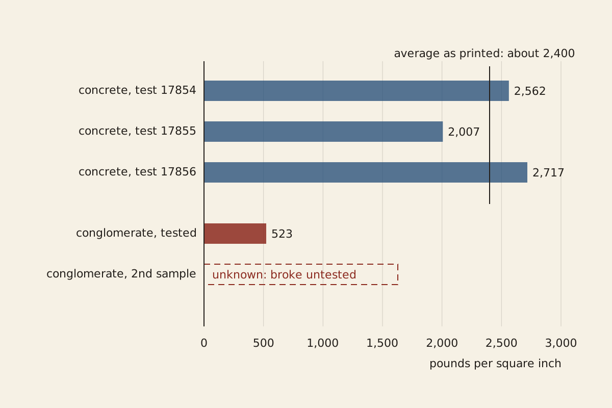
Figure: From the Surviving Record, CC BY 4.0
Full credit line for reuse
"Compression tests of the concrete and the foundation rock" by From the Surviving Record, CC BY 4.0. Source: https://fromthesurvivingrecord.com/failures/st-francis-dam/ — License: https://creativecommons.org/licenses/by/4.0/
Data: Report of the Commission appointed by Governor C. C. Young to investigate the causes leading to the failure of the St. Francis Dam (1928), retrieved 2026-11-01, public domain in the United States
The commission was careful about the order of events. It wrote that “the manner and chronological order” of the failure “are not entirely certain.” Even so, every fragment from the west end had been carried downstream, and the commission read where they lay as marking that end as the start. By the report's reading, water seeping into the foundation near the fault had softened the conglomerate, and “either a blowout under, or a settling of the concrete at this place, or both” followed.
According to the report, the water released at the west end then probably scoured the schist at the foot of the east side and brought that part down. The escaping water cut as deep as about 30 feet (9 m) below the original foundation. For the middle section, the report gives an apparent movement at the top of only some 5.5 inches downstream and 6 inches toward the east.
The dam had no inspection gallery, a tunnel through the dam for checking leaks, and no pressure grouting under it. Drains to relieve water pressure from below were placed only under the center, which the report notes is where the dam still stood, adding that “this is probably merely a coincidence.” Such measures, it judged, “would have ameliorated the conditions and postponed the final failure,” but were unlikely to have been enough. In its words, “with such a formation, the ultimate failure of this dam was inevitable, unless water could have been kept from reaching the foundation.”
By dead reckoning, the commission's reasoning puts the decisive choice in the site rather than in the drawings. It judged the design sound and the sealing measures unlikely to work, which leaves keeping water off the conglomerate or building elsewhere. The report does not say whether the rock was ever tested in water before construction began in 1924.
The commission's report was not the last study of the failure. Later work includes J. David Rogers, “A Man, A Dam and A Disaster: Mulholland and the St. Francis Dam” (Southern California Quarterly, 1995). That study is listed here by its catalog record only; what it argues is not summarized or weighed against the report.
What did the commission conclude?
The report closes with three numbered conclusions, signed by all six members. The first is a single sentence: “The failure of St. Francis Dam was due to defective foundations.” The second says “there is nothing in the failure” to show that “the accepted theory of gravity dam design is in error.” As evidence, it points to “the action of the middle section which remains standing.”
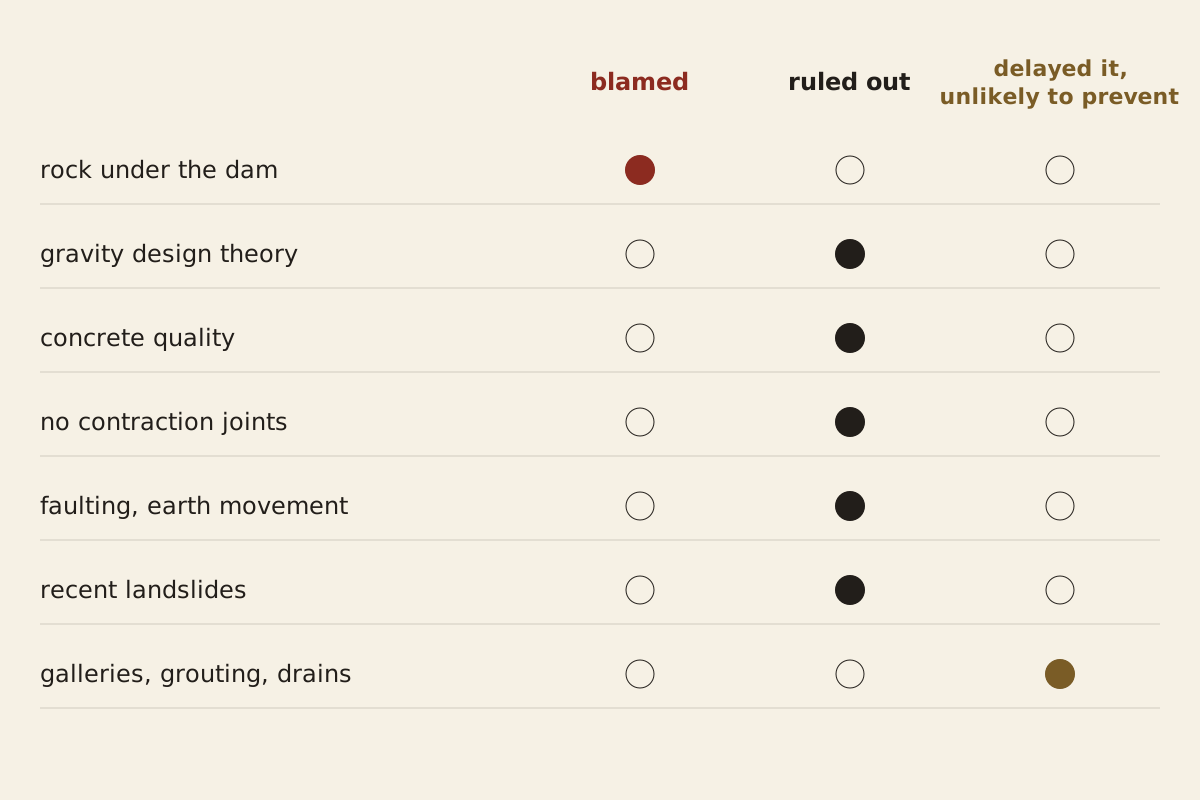
Figure: From the Surviving Record, CC BY 4.0
Full credit line for reuse
"What the 1928 commission blamed and ruled out" by From the Surviving Record, CC BY 4.0. Source: https://fromthesurvivingrecord.com/failures/st-francis-dam/ — License: https://creativecommons.org/licenses/by/4.0/
Data: Report of the Commission appointed by Governor C. C. Young to investigate the causes leading to the failure of the St. Francis Dam (1928), retrieved 2026-11-01, public domain in the United States
| Factor | Commission's finding | Words of the report |
|---|---|---|
| Rock under the dam | Blamed | “due to defective foundations” (p. 18) |
| Theory of gravity dam design | Ruled out | “nothing in the failure … to indicate” it “is in error” (p. 18) |
| Quality of the concrete | Ruled out | “of satisfactory quality and adequate strength” (p. 15) |
| No contraction joints | Ruled out | “can not be attributed to their absence” (p. 15) |
| Faulting or major earth movement | Ruled out | no reason to think it was “to any degree responsible” (p. 13) |
| Recent landslides | Ruled out | took place “after and as a result of” the failure (p. 13) |
| Galleries, grouting, drains, cut-off walls | Would have delayed, unlikely to have prevented | “postponed the final failure” (p. 16) |
Download the table (CSV, st-francis-dam-factors.csv) (file notes: sources and license) Data: Report of the Commission appointed by Governor C. C. Young to investigate the causes leading to the failure of the St. Francis Dam (1928), retrieved 2026-11-01, public domain in the United States
The commission worked fast. It first met in Los Angeles on March 19, 1928, and dated its report five days later, 12 days after the failure. For a 1908 inquiry that looked to the design of a bridge rather than the ground under it, see Quebec Bridge Collapse: The 1908 Inquiry Blamed Chord Design. For an inquiry into a ship lost at sea in 1915, see RMS Lusitania: Witnesses Disagree on a Second Explosion.
Download the table (CSV, st-francis-dam-conclusions.csv) (file notes: sources and license) Data: Report of the Commission appointed by Governor C. C. Young to investigate the causes leading to the failure of the St. Francis Dam (1928), retrieved 2026-11-01, public domain in the United States
What changed after the report?
The commission's third conclusion is where the quiet retrofit would begin, the trail of design or rule changes that can be traced after a failure. It asked for change, in these words: the failure showed “the desirability of having all such structures erected and maintained under the supervision and control of state authorities.” The state's police power, it added, “certainly ought to be extended to cover all structures impounding any considerable quantities of water.”
The report also recorded its reason. “While the benefits accrue to the builders of such projects,” it said, “the failures bring disaster to others who have no control over the design, construction and maintenance of the works.” Governor Young's letter of April 20, 1928, says the report “is herewith placed in the hands of the public.”
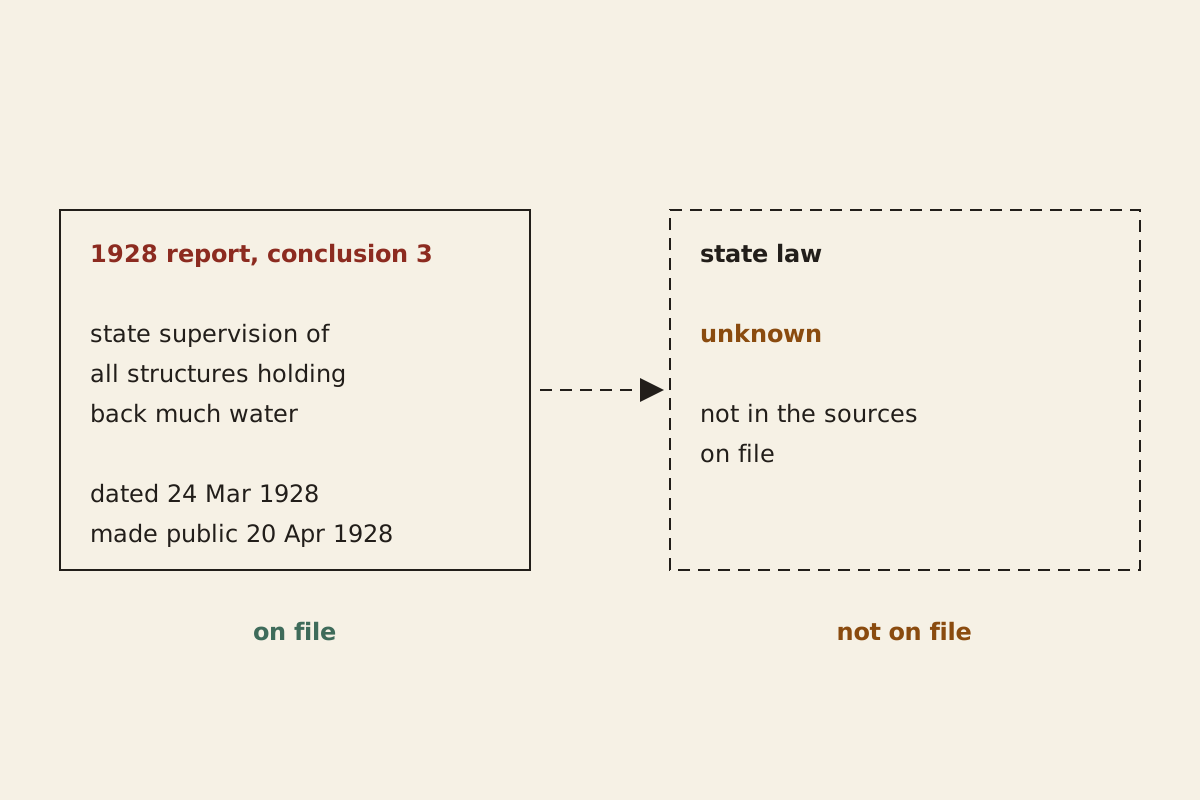
Figure: From the Surviving Record, CC BY 4.0
Full credit line for reuse
"After the report: the recommendation on file, any law not on file" by From the Surviving Record, CC BY 4.0. Source: https://fromthesurvivingrecord.com/failures/st-francis-dam/ — License: https://creativecommons.org/licenses/by/4.0/
Data: Report of the Commission appointed by Governor C. C. Young to investigate the causes leading to the failure of the St. Francis Dam (1928), retrieved 2026-11-01, public domain in the United States
What happened next is outside the sources on file. A recommendation is not a statute, and no California law on dam supervision is among the documents read for this page, so no date for one is given here. The governor's foreword drew its own lesson: that dams “can be built with entire safety when due regard is paid to suitability of foundations and correctness of design.”
The middle section the commission held up as evidence for the design still stood when its members signed the report. What the state did with the third conclusion is the part of this record not yet on file.
Still missing:
- Whether California passed the law the third conclusion asked for, and when. The report recommends state supervision of every dam that holds back much water; no statute is among the sources on file.
- Which part of the dam gave way first. The commission read the scattered fragments as pointing to the west end, but called the order “not entirely certain.”
- How a foundation finding compares with a failure traced to one part inside a structure. The Silver Bridge, which the NTSB dates as completed in 1928, the year this dam failed, came down in 1967: Silver Bridge Collapse: NTSB Traced It to One Hidden Crack.
Cite this page
From the Surviving Record. “St. Francis Dam: The 1928 Inquiry Blamed the Rock Beneath It.” First published 2026-11-01. https://fromthesurvivingrecord.com/failures/st-francis-dam/ (accessed add the date you read it).
Sources
- A. J. Wiley, George D. Louderback, F. L. Ransome, F. E. Bonner, H. T. Cory and F. H. Fowler, Report of the Commission Appointed by Governor C. C. Young to Investigate the Causes Leading to the Failure of the St. Francis Dam near Saugus, California (State of California, 1928), dated March 24, 1928. damfailures.org/sites/default/files/wp-pdf/IR_St.-Francis.pdf Read: full report (pages 4–21), including the description of the dam, the failure, the geology, the causes, the three conclusions, the governor's letters and the laboratory test sheets; plates not used.
- H. T. Stearns, U.S. Geological Survey, photograph of the St. Francis Dam site after the failure, March 17, 1928 (USGS photographic library, Stearns, H.T. 665), via Wikimedia Commons. commons.wikimedia.org/wiki/File:St._Francis_Dam_after_the_1928_failure.jpg Read: the photograph and its file record.
- J. David Rogers, “A Man, A Dam and A Disaster: Mulholland and the St. Francis Dam,” Southern California Quarterly 77, no. 1–2 (1995): 1–109. doi.org/10.2307/41171757 Read: bibliographic record only.

Spotted an error? Write to contact@fromthesurvivingrecord.com (the link fills in this page's title as the subject). Changes are logged in the corrections log and at the foot of the entry; the evidence levels page explains how sources are weighed.
Related entries
-
Engineering Failures
Silver Bridge Collapse: NTSB Traced It to One Hidden Crack
Why did the Silver Bridge fall in 1967? The NTSB traced it to one eyebar's hidden flaw. Its cause, the two-bar chain, and the inspection rule that followed.
Picture credit
Illustration: From the Surviving Record. Generated schematic image — not a photograph or historical record. © From the Surviving Record, all rights reserved.
-
Engineering Failures
Quebec Bridge Collapse: The 1908 Inquiry Blamed Chord Design
Why did the Quebec Bridge collapse in 1907? Canada's 1908 Royal Commission blamed the design of its lower chords and found its weight had been set too low.
Picture credit
"Pont de Québec vers 1917" by William Notman and Son — https://commons.wikimedia.org/wiki/File:Pont_de_QC_1917_Notman.jpg — Public domain (Canada: photograph made before 1 January 1949 (PD-Canada); US: published before 1931 (PD-US-expired on the file page); EU: a studio work with no individual photographer named on the file page or in the museum record, treated as an anonymous work under the site ruling of 1 November 2026; published before 1931 (PD-US-expired on the file page), so more than 70 years have passed since publication)