Dead Reckoning: Why Bowditch Advised Shorter Log-Line Knots
Published Last substantive revision
How to read this page: each point is marked as a cross-checked fix, a single record (“according to”), or inference (“by dead reckoning”).
TL;DR: In Nathaniel Bowditch's 1802 New American Practical Navigator, dead reckoning is the account of a ship's position worked from her run since the last observation: the courses steered, her speed and the time. In the same book, speed came from a log line knotted every 51 feet and timed with a half-minute sand glass, and Bowditch advised marking the knots 3 or 4 feet shorter because, he wrote, ships generally over-ran their reckoning.
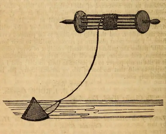
“Example of a Chip log, 1835” by Charles Ellms, Public Domain Mark
Full credit
"Example of a Chip log, 1835" by Charles Ellms — https://commons.wikimedia.org/wiki/File:Example_of_a_Chip_log,_1835_-_tragedyofseasors01ellm_0242.jpg — Public domain (US: published in 1848, before 1931; EU: the woodcut’s engraver is not named and it was published in 1848, so the creator is presumed to have died more than 70 years ago (presumed))
What was dead reckoning?
In 1802, Nathaniel Bowditch's navigation manual worked out that the knots on a log line should be 51 feet apart. The knots were marks that divided the line into equal spaces. Two sentences later he advised making them 3 or 4 feet shorter, because in many trials ships had run ahead of their reckoning. Both figures sit on page 129 of The New American Practical Navigator, printed at Newburyport, Massachusetts.
The method those knots served is defined more than a hundred pages later. “Dead Reckoning is that account deduced from the ship's run from the last observation,” Bowditch wrote.
The starting point was the last observation: in the manual, the bearing of a known point of land as the coast dropped astern, or at sea a sight of the sun, which gave the latitude. From there her position was carried forward by the courses she had steered and the distances she had run.
W. H. Smyth's The Sailor's Word-Book, published in London in 1867, defines dead reckoning along the same lines, as a position worked out from the distance run by the log and the courses steered by the compass. Smyth adds allowances “for current, lee-way, &c.” and says the reckoning “should be corrected by astronomical observations.” His preface says he “freely availed” himself of earlier compilers, so the two definitions may come from the same older books.
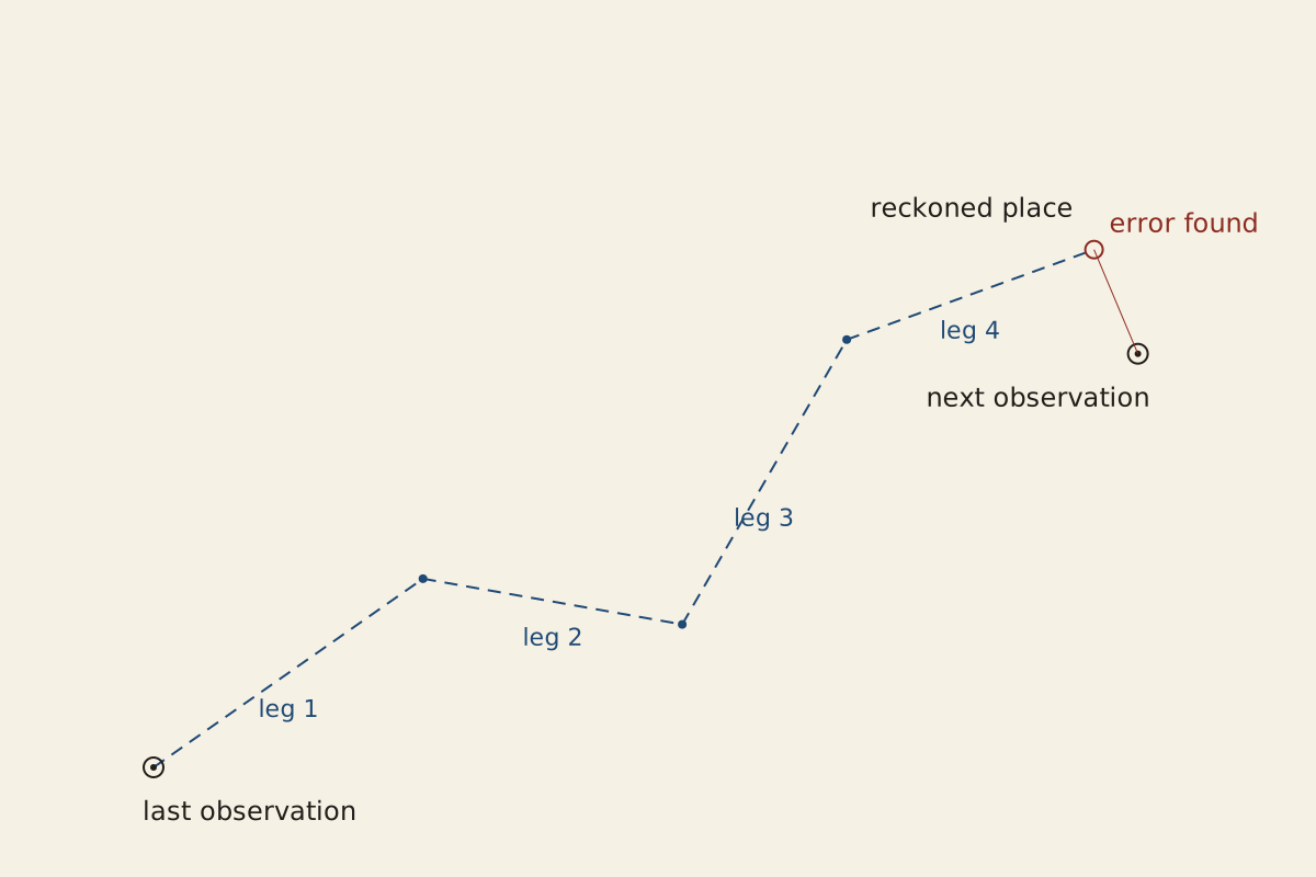
Figure: From the Surviving Record, CC BY 4.0
Full credit line for reuse
"Dead reckoning: a reckoned track between two observations" by From the Surviving Record, CC BY 4.0. Source: https://fromthesurvivingrecord.com/shipwrecks/dead-reckoning/ — License: https://creativecommons.org/licenses/by/4.0/
Data: Nathaniel Bowditch, The New American Practical Navigator (Newburyport, 1802), retrieved 2026-11-01, public domain
How did a ship measure her speed?
Bowditch calls the log and half-minute glass the method “most in use” for finding how fast a ship sailed. The log was “a flat piece of thin board,” shaped like a slice of a circle and weighted with lead along its curved edge so that it floated upright. A line of about 150 fathoms ran from it to a reel. The glass was a small sand glass that emptied in half a minute.
Heaving the log took three people in Bowditch's account. One held the reel and another the glass, while an officer of the watch threw the log over the stern on the lee side. About ten fathoms of stray line ran out first, to carry the log clear of the eddy in the ship's wake. A red rag marked where the count began.
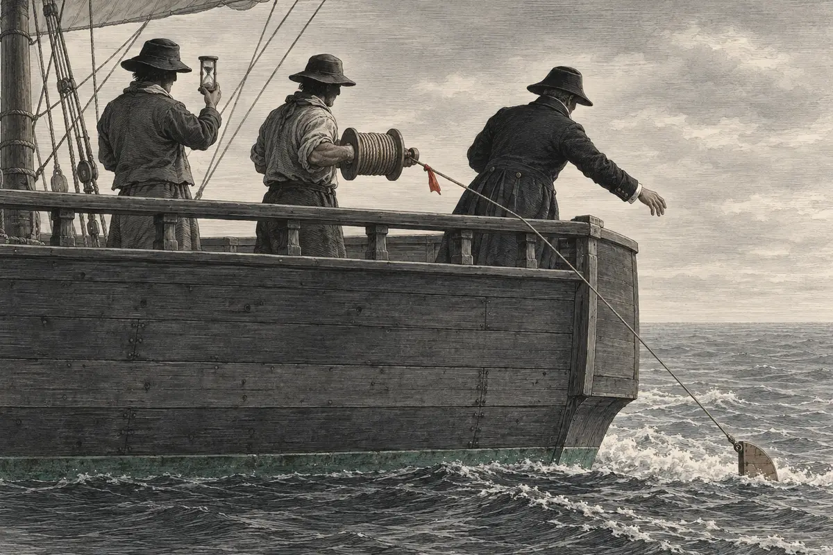
Illustration: From the Surviving Record. Generated schematic image — not a photograph or historical record. © From the Surviving Record, all rights reserved.
As the rag ran off the reel, the manual says, the officer cried “turn!” and the glass holder answered “done!” When the sand ran out, the glass holder called “stop!” and the reel was held. The knots that had run off gave the speed, and the part of a knot past the last mark gave the fraction.
That reading stood for the whole hour, Bowditch adds, only “if the wind has been constant.” Changes of wind or sail were left to “the discretion of the artist,” the navigator. With a big sea running after the ship, the log could be dragged back toward her, and then “it is customary to allow one mile in ten.”
The log line was not the only way. Smyth's dictionary of 1867 records an older method, still used then “in some colliers”: a log or chip was thrown overboard well forward, and someone walked aft keeping pace with it until it passed the stern, “thus estimating (and closely too by practice) the rate of motion.” By then, Smyth adds, Massey's Patent Log “gives the most accurate measurement.”
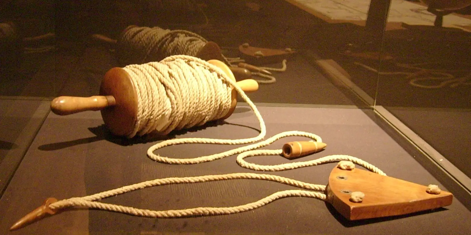
"Speyer Handlog" by Lokilech — https://commons.wikimedia.org/wiki/File:Speyer_Handlog.jpg — CC BY-SA 3.0 (https://creativecommons.org/licenses/by-sa/3.0/)
Why were the knots 51 feet apart?
The arithmetic rests on one rule, which Bowditch states plainly: each knot is “the same part of a sea mile, as half a minute is of an hour.” Half a minute is 1/120 of an hour. Bowditch's figure for a sea mile was “about 6120 feet,” and 1/120 of that is 51 feet. A ship that ran out five knots before the glass emptied was making five sea miles an hour.
For a glass that ran only 28 seconds, he wrote, the knot “ought to be 47 feet and 6 tenths.” The same rule gives 6,120 × 28 ÷ 3,600, which is 47.6.
Fix: a knot of 51 feet for a 30-second glass and 47.6 feet for a 28-second one. These are the figures Bowditch printed, and working them again from his own inputs gives the same two numbers exactly.
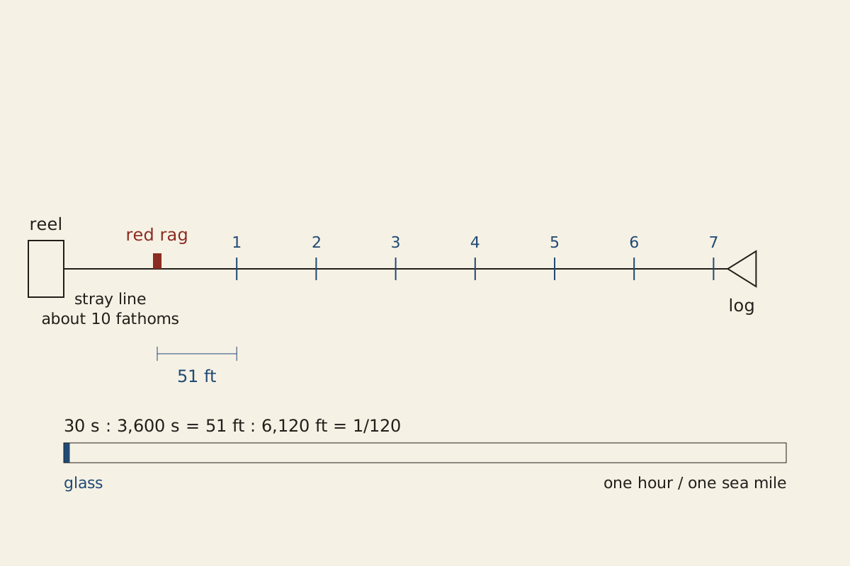
Figure: From the Surviving Record, CC BY 4.0
Full credit line for reuse
"A log line knotted every 51 feet, timed by a half-minute glass" by From the Surviving Record, CC BY 4.0. Source: https://fromthesurvivingrecord.com/shipwrecks/dead-reckoning/ — License: https://creativecommons.org/licenses/by/4.0/
Data: Nathaniel Bowditch, The New American Practical Navigator (Newburyport, 1802), retrieved 2026-11-01, public domain
Bowditch also split each knot into 10 parts that he calls fathoms. On a 51-foot knot those parts are 5.1 feet, not the 6 feet of an ordinary fathom. His rules for a faulty log then start from a rounder number, “supposing that a 30″ glass requires 50 feet to a knot.” A footnote tells anyone who marks the line at less than 50 feet for a 30-second glass to use “his estimated length of the knot” in place of 50.
The worked cases come out as printed. A ship logging 8½ knots by a glass that ran 36 seconds was making 7.1. One logging 7 knots on a line with 53-foot knots was making 7.4 miles an hour.
Why did Bowditch mark the knots short?
“These are the lengths generally recommended in books of navigation,” Bowditch wrote of 51 and 47.6 feet, “but it may be observed, that in many trials it has been found, that a ship will generally over-run her reckoning with a log-line thus marked.” His advice was to “shorten the above measures by 3 or 4 feet,” making the knot “7 or 7½ fathoms of 6 feet each” for a 28-second glass. That is 42 or 45 feet. Taking 3 or 4 feet off 47.6 leaves 44.6 or 43.6, so the two pairs of figures do not match exactly, and the book does not say how the fathoms were rounded.
By dead reckoning, a shorter knot made the log read faster: with a 28-second glass, a line knotted at 44.6 feet counts about 6.7 percent more knots than one at 47.6 for the same run, and a line at 42 feet about 13.3 percent more. Bowditch's “safe side” was then a reckoning that ran ahead of the ship rather than behind her, so that land would be expected early rather than late. He does not spell this out. The reading rests on his phrase “over-run her reckoning” and on which way the shorter knots move the count.
Smyth's dictionary of 1867 says the knots “ought to be 47 feet 4 inches from each other, though it was the common practice at sea not to have them above 42 feet.” Which glass his 47 feet 4 inches assumes, the entry does not say. His entry on the glass itself gives “28 seconds” for slow sailing and 14 for fast.
Bowditch's 7 fathoms and Smyth's upper limit are both 42 feet, but one is a recommendation and the other a report of practice. Smyth's entry may draw on the same “books of navigation” Bowditch mentions, so the match is not a separate check on either.
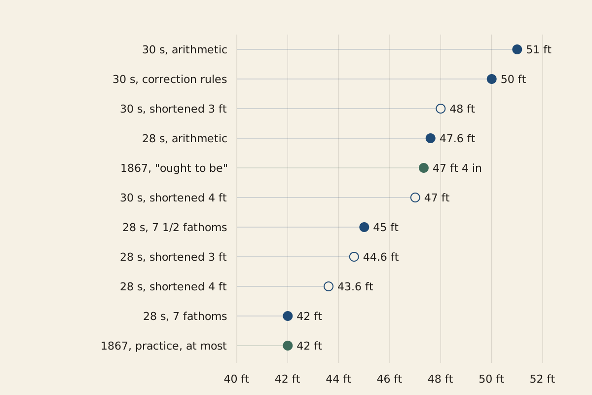
Figure: From the Surviving Record, CC BY 4.0
Full credit line for reuse
"Knot spacings in Bowditch (1802) and Smyth (1867)" by From the Surviving Record, CC BY 4.0. Source: https://fromthesurvivingrecord.com/shipwrecks/dead-reckoning/ — License: https://creativecommons.org/licenses/by/4.0/
Data: Nathaniel Bowditch, The New American Practical Navigator (Newburyport, 1802), retrieved 2026-11-01, public domain; W. H. Smyth, The Sailor's Word-Book, revised by E. Belcher (London, 1867), retrieved 2026-11-01, public domain
| Knot spacing | Glass | What the figure is | Source |
|---|---|---|---|
| 51 ft | 30 seconds | the arithmetic | Bowditch 1802, p. 129 |
| 50 ft | 30 seconds | basis of the correction rules | Bowditch 1802, p. 130 |
| 47.6 ft | 28 seconds | the arithmetic | Bowditch 1802, p. 129 |
| 47 ft 4 in | not stated | what the spacing “ought to be” | Smyth 1867 |
| 45 ft | 28 seconds | recommended: 7½ fathoms | Bowditch 1802, p. 130 |
| 42 ft | 28 seconds | recommended: 7 fathoms | Bowditch 1802, p. 130 |
| 42 ft | not stated | upper limit in common practice, per Smyth | Smyth 1867 |
Download the table (CSV, dead-reckoning-log-line-spacing.csv) (file notes: sources and license) Data: Nathaniel Bowditch, The New American Practical Navigator (Newburyport, 1802), retrieved 2026-11-01, public domain; W. H. Smyth, The Sailor's Word-Book, revised by E. Belcher (London, 1867), retrieved 2026-11-01, public domain
The line and the glass could both drift. Bowditch told officers to “measure the log-line pretty often, lest it stretch and deceive you in the distance.” The glass, he warned, ran “slower in damp weather than in dry,” and he gave a check: a musket ball on a thread 39⅛ inches long swings once a second.
How was the course kept?
Distance was half of each entry. Direction was the other half. Bowditch describes a log-board, a board or slate kept “in the steerage,” ruled in seven columns: the hours, the knots and fathoms run, the courses steered by compass, the winds, the leeway, and remarks. Leeway is the angle between the course a ship was steered and the course she actually made, as wind or sea pushed her sideways.
The board's remarks were copied daily into the log-book, which Bowditch calls “the only authentic record of the ship's transactions.” One column drew a complaint. It would help the reckoning, he wrote, if leeway were marked every watch, “instead of leaving it till the day's work is calculating, and then guessing at it, as is the general practice.” How far a famous story can drift from a ship's own record is the subject of the Mary Celeste entry.
Smyth's dictionary describes a second device, the traverse board: “a thin circular piece of board, marked with all the points of the compass, and having eight holes bored in each, and eight small pegs hanging from the centre of the board.” One peg went into the point the ship had run on for each half hour of a watch. Eight half hours make four hours, the usual length of a watch in Bowditch's account.
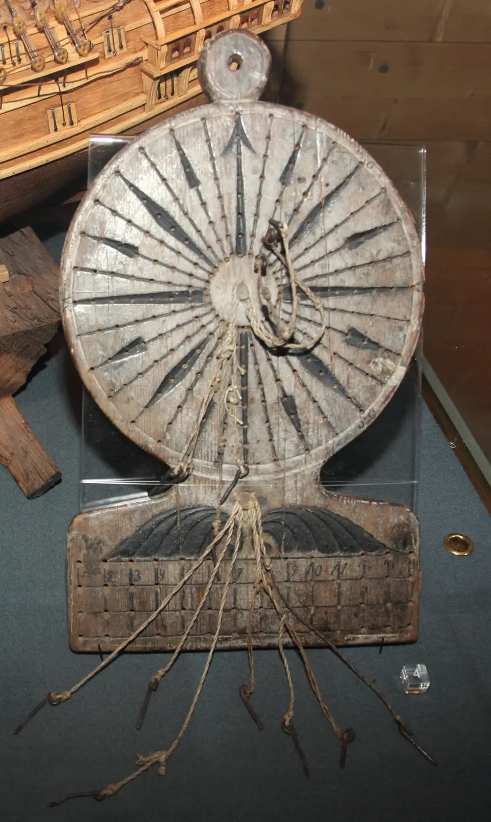
"Traverse board Forum Marinum" by MKFI — https://commons.wikimedia.org/wiki/File:Traverse_board_Forum_Marinum.jpg — Public domain (US and EU: released into the public domain worldwide by the photographer, MKFI (PD-self), taken as the author’s own public-domain dedication)
How did small errors grow?
Every entry could carry a small error, and errors that leaned the same way added up. Bowditch's rules for correcting a reckoning say where the error most probably lay.
A point is one of the 32 divisions of the compass, 11¼ degrees. When the ship's course lay within three points of north or south, an error in latitude was, by his rule, “probably in the distance.” When it lay more than five points from that line, the error was “probably in the course,” because a small error in the course “would cause a considerable error in the difference of latitude.”
By dead reckoning, with numbers chosen for illustration rather than taken from any log, a course held 1 degree wrong for 100 miles leaves a ship about 1.7 miles off her intended line. Five degrees leaves 8.7 miles, and a full point leaves 19.5. Each figure is worked twice, once by trigonometry and once by adding up the run in short legs, and the two agree.
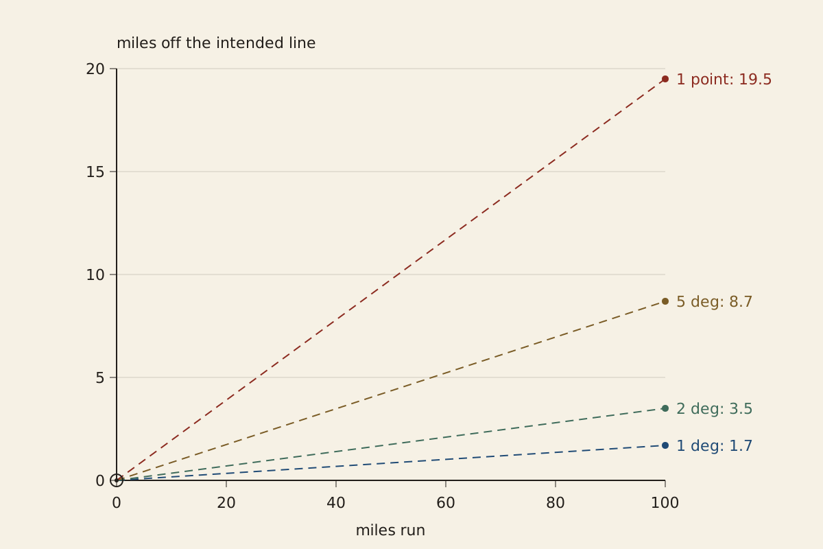
Figure: From the Surviving Record, CC BY 4.0
Full credit line for reuse
"Miles off the intended line after a steady course error" by From the Surviving Record, CC BY 4.0. Source: https://fromthesurvivingrecord.com/shipwrecks/dead-reckoning/ — License: https://creativecommons.org/licenses/by/4.0/
Data: Nathaniel Bowditch, The New American Practical Navigator (Newburyport, 1802), retrieved 2026-11-01, public domain
| Course error | Miles off the line after 100 miles |
|---|---|
| 1 degree | 1.7 |
| 2 degrees | 3.5 |
| 5 degrees | 8.7 |
| 1 point (11¼ degrees) | 19.5 |
Download the table (CSV, dead-reckoning-error.csv) (file notes: sources and license) Data: Nathaniel Bowditch, The New American Practical Navigator (Newburyport, 1802), retrieved 2026-11-01, public domain
Currents called for a separate measurement. Bowditch defines the set of a current as the compass point “towards which the waters run” and its drift as “the rate it runs per hour.” To measure an unknown one, he has three or four men take a boat a little way off, lower a heavy iron pot on a rope to 80 or 100 fathoms as a drag, and heave the log from the boat.
Once known, a current was handled as a second voyage. “All cases of sailing in a current are calculated upon the principle, that the ship is affected in the same manner by the current, as if she had sailed in still water, with an additional course and distance exactly equal to the course and set of the current,” Bowditch wrote.
In his example a ship sails 98 miles north-east by north while a current carries her 27 miles south by west. He gives her course made good as north-east a quarter north, “74 miles nearly.”
Worked again as the sum of two arrows, the example gives 73.8 miles at 41.8 degrees east of north. North-east a quarter north is 42.2 degrees, so the result and Bowditch's printed answer differ by less than half a degree.
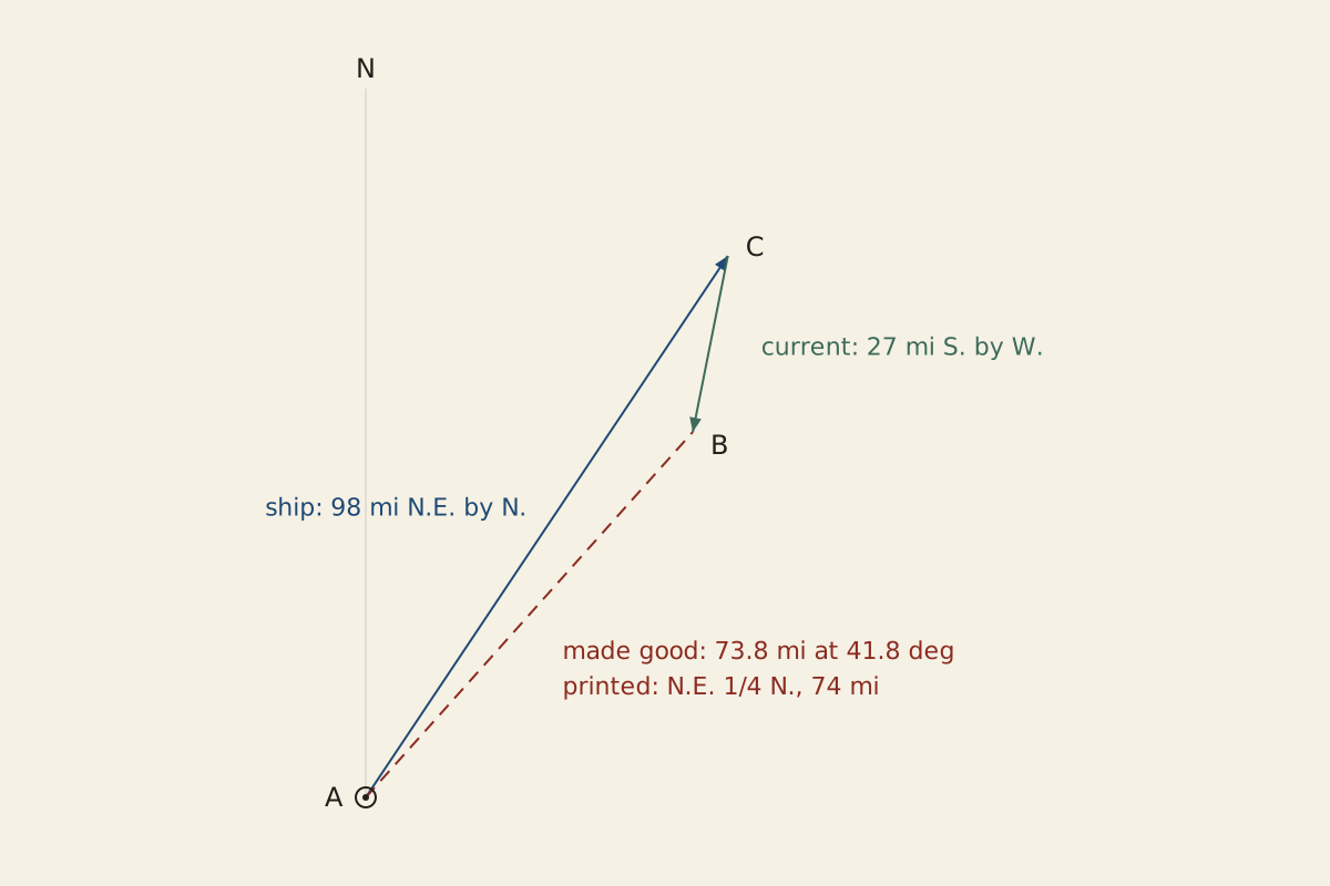
Figure: From the Surviving Record, CC BY 4.0
Full credit line for reuse
"Bowditch's current example: course and distance made good" by From the Surviving Record, CC BY 4.0. Source: https://fromthesurvivingrecord.com/shipwrecks/dead-reckoning/ — License: https://creativecommons.org/licenses/by/4.0/
Data: Nathaniel Bowditch, The New American Practical Navigator (Newburyport, 1802), retrieved 2026-11-01, public domain
Download the table (CSV, dead-reckoning-bowditch-examples.csv) (file notes: sources and license) Data: Nathaniel Bowditch, The New American Practical Navigator (Newburyport, 1802), retrieved 2026-11-01, public domain
What reset the reckoning?
An observation did. After each day's work, Bowditch tells the navigator to compare “the latitude by dead reckoning with the latitude by observation.” If they differ, the log line, the glass, the steering, the allowances for leeway and variation all come under suspicion, “but above all” the chance of an unknown current.
His first worked case shows what a correction looked like. A ship at 39°18′ N one noon had made 107 miles of southing and 64 of westing by her reckoning at the next. The noon sight put her at 37°48′ N, which in Bowditch's working is 90 miles of southing. The reckoning had run 17 miles ahead of the observed latitude, about 16 percent of the southing it claimed.
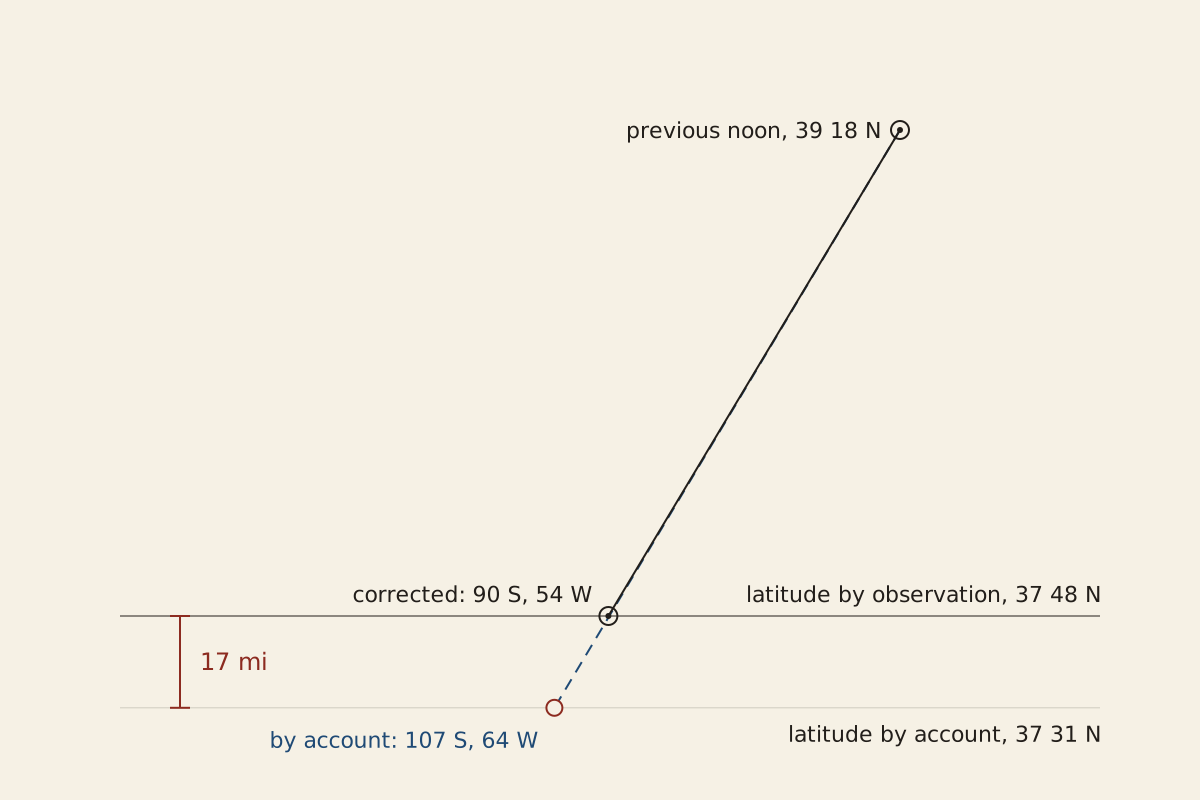
Figure: From the Surviving Record, CC BY 4.0
Full credit line for reuse
"Bowditch's Case I: the reckoning against the noon latitude" by From the Surviving Record, CC BY 4.0. Source: https://fromthesurvivingrecord.com/shipwrecks/dead-reckoning/ — License: https://creativecommons.org/licenses/by/4.0/
Data: Nathaniel Bowditch, The New American Practical Navigator (Newburyport, 1802), retrieved 2026-11-01, public domain
By dead reckoning, the example errs the opposite way from the trials Bowditch reported: there ships ran ahead of their reckoning, while here the account placed the ship farther along than she was. It is a teaching example, though, and the book does not say it came from a real voyage.
An observation also needed something to observe. On May 7, 1915, according to the British inquiry into the loss of the Lusitania, the captain sighted land he took to be Brow Head but “could not, however, identify it with sufficient certainty to enable him to fix the position of his ship upon the chart.” The same question, when a reckoned position may be trusted, runs through the polar journeys in Roald Amundsen and Scott.
Ernest Shackleton's South records that when the boats neared Elephant Island in April 1916, the island lay “on the bearings that Worsley had laid down,” after “two days dead reckoning” through pack ice. Later, on the boat voyage from Elephant Island to South Georgia, the book records “six days out without an observation, and our dead reckoning naturally was uncertain.” How far that reckoning had drifted before the sun came out, South does not say.
Still missing:
- How much a log line stretched in use. Bowditch warns that the line should be measured “pretty often, lest it stretch,” but gives no figure for how much it did.
- What position the Lusitania's officers had reckoned that afternoon. The 1915 inquiry gives courses, times and a distance off the Old Head of Kinsale rather than a reckoned latitude and longitude; that afternoon is traced in the Lusitania entry.
- How the James Caird's position was carried between sights. South prints no reckoned positions for the crossing to South Georgia; the voyage itself is followed in the Shackleton Expedition.
Cite this page
From the Surviving Record. “Dead Reckoning: Why Bowditch Advised Shorter Log-Line Knots.” First published 2026-11-01. https://fromthesurvivingrecord.com/shipwrecks/dead-reckoning/ (accessed add the date you read it).
Sources
- Nathaniel Bowditch, The New American Practical Navigator; Being an Epitome of Navigation (Newburyport, Mass.: Edmund M. Blunt, for Cushing and Appleton, Salem, 1802), pp. 129–130, 235–241. archive.org/details/newamericanpract00bowd Read: pages 129–130 and 235–241, checked against the page images.
- W. H. Smyth, The Sailor's Word-Book: An Alphabetical Digest of Nautical Terms, revised for the press by Sir E. Belcher (London: Blackie and Son, 1867), preface and entries “Dead-reckoning,” “Log-glass,” “Log-line and log-ship” and “Traverse-board.” Project Gutenberg eBook #26000. www.gutenberg.org/ebooks/26000 Read: full text of the preface and the cited entries.
- Ernest Shackleton, South: The Story of Shackleton's Last Expedition 1914–1917 (London: William Heinemann, 1919), with appendices by the expedition's scientists. Project Gutenberg eBook #5199. www.gutenberg.org/ebooks/5199 Read: full text.
- Board of Trade, Shipping Casualties (Loss of the Steamship "Lusitania"): Report of a Formal Investigation into the circumstances attending the foundering on 7th May, 1915, of the British Steamship "Lusitania," of Liverpool, Lord Mersey, Wreck Commissioner (London: HMSO, 1915), Cd. 8022. archive.org/details/shippingcasualti00grea_0 Read: full report, with the annex and the court's answers to the 21 questions.
Spotted an error? Write to contact@fromthesurvivingrecord.com (the link fills in this page's title as the subject). Changes are logged in the corrections log and at the foot of the entry; the evidence levels page explains how sources are weighed.
Related entries
-
Shipwrecks & Seafaring
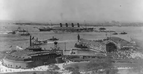
RMS Lusitania: Witnesses Disagree on a Second Explosion
How the Lusitania sank on May 7, 1915: the British inquiry found two torpedoes and 1,198 lives lost; a 1918 U.S. court said about 18 minutes. Timeline, CSV.
Picture credit
"The "Lusitania's" first appearance in New York Harbor, Sept. 13, 1907" by Unknown photographer — https://commons.wikimedia.org/wiki/File:The_%22Lusitania%27s%22_first_appearance_in_New_York_Harbor,_Sept._13,_1907._LCCN2002721293.jpg — Public domain (US: a 1907 photographic print entered with the U.S. Copyright Office (Library of Congress record notes H100466), published before 1931; EU: no photographer is named and the print was made public in 1907, so the 70-year term for anonymous works has ended); modified: cropped: the typed title line and the sky above it at the top, and the print edges on all four sides, removed; ship, harbor and waterfront untouched
-
Shipwrecks & Seafaring
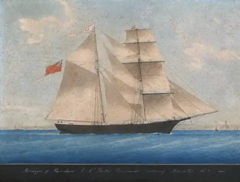
Mary Celeste: Conan Doyle's 1884 Story Called Her 'Marie'
The Mary Celeste was found with no one aboard in 1872, her boat gone, per testimony Fay printed. Conan Doyle's 1884 story called her Marie and kept her boats.
Picture credit
"Brigantine Amazon entering Marseilles, November 1861" by Unknown painter — https://commons.wikimedia.org/wiki/File:Mary_Celeste_as_Amazon_in_1861.jpg — Public domain (US and EU: painting dated 1861 by its inscription; painter unknown, so the author is presumed to have died more than 70 years ago (presumed, per the site's rule for anonymous works of the 1860s and earlier); a faithful photograph of a flat artwork adds no new rights)